Wednesday, August 28, 2013

Olympic-Level Stompin', Part 03

Last lap, then it's home for ice cream and beer.


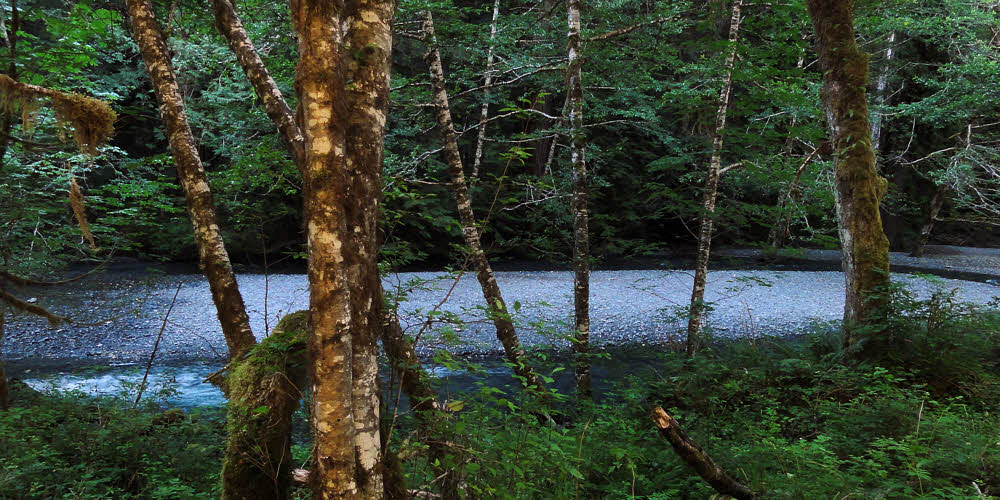
North Fork Quinault River. (click/embiggen)

After leaving the Quinault River's East Fork, I did the 10-mile road walk and found a campsite just short of the North Fork Campground, which is closed, because the river took it. The last time through here things were the same as they always had been, with the river past the campground, but the river, full up after munching the campground, had permanently moved itself a quarter-mile off, which is where I found it, and washed, and ate, and then returned to the forest where I rolled into my hammock for the night.


Quinault River Trail.

With morning, things looked like rain, but the sky lied. It was only a high fog and not rain clouds. Still, the valley was still and full of gloom, though it remained cool the whole day because of the fog.


Wild Rose Creek crossing (formerly a ford). (click/embiggen)

As with the rest of the trip, the higher I got, the more trees lay across the trail, but that was later. Earlier on I got to see many previously-familiar locations in unfamiliar configurations. Luckily, the key bridges were intact since they were all tens of feet above their streams, though Wild Rose Creek, which used to be a wide and shallow ford, was gouged, a mess of scattered and tumbled rock.


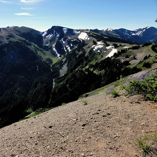
High dry fog. (click/embiggen)

From there on it was mostly uneventful, head-down trudging and never-ending tree-hopping.


Where to hang food if using established campsites.

One thing that may or may not be familiar everywhere is a "bear wire". This is like the two-tree food hang, but put up by park staff, and consisting of chew-proof wire instead of cordage. Olympic National Park is chock full of bears (though I saw none this trip), and the typical backpacker is an idiot, scattering food, leaving soiled cookware sitting out, and not storing things properly.


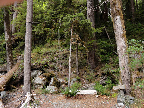
Bear-defeating food-hanging wire.

Bear wires help, by preventing bears, raccoons, skunks, porcupines, mice, and other residents from learning how easy it is to get a free meal. Some of them, mainly bears and raccoons, eventually learn how to bring down food hung conventionally, and become "problem animals". Until they are hauled off to a zoo or killed. Too bad the guilty backpackers don't suffer the same fate.


On? On what?

Someone was kind enough to leave a reminder of what to do, I stopped dawdling and got back to hiking.


On the way to Low Divide and the Elwha River.

Not quite halfway, at Elip Creek, there is a reminder, one which says that it's too far to go back, and too far to go on – overall, too much trugding to do anyone any good, but only one option led home, so I kept going.


Feeder stream flowing under a bridge.

Here is one of those side streams, as seen from the bridge over it. Everything looks normal back here, far enough away from the Quinault to have avoided much flooding, but that is partly because little canyons like this are solid rock and have nothing for floods to tear out of them.


A large mountain toad.

Up higher, one of those huge mountain toads the size of both your hands together hopped across the trail and settled in beneath some ferns. It's always amazing to see a toad this big so far up in the mountains, but the toads may well think the same about backpackers. Neither of us bothered the other, which is just as well. I think it could have taken me. I never was a match for a back full of warts.


Upper North Fork ford.

After negotiating endless deadfalls it was time to ford the river. I can't remember how this place looked before, but don't recall a ford – there must have been a bridge here, now long gone downstream and forgotten. A group of women was camped on the gravel bar. One of them amused herself by watching me inch across while straddling the only log that spanned the river. But anything is better than wading.


Another feeder stream.

Another crossing that made me glad to have an intact bridge.


Morning at Low Divide. (click/embiggen)

Low Divide is a large meadow, and prime bear country, especially early, when bears like to graze, but the bear were elsewhere when I passed through. The air was chilly and the grasses still dripped with dew as I passed the ranger cabin, but there was no ranger this year because of funding cuts. A man and two or three boys were poking at breakfast but otherwise things were quiet.


Lake Margaret, north side of Low Divide.

Right over the pass there are two lakes, Margaret and Mary, both lovely, especially in morning sunlight.


Lake Mary, north side of Low Divide.

One lake is larger than the other but I don't remember which, or if it matters. Unless you're camped at the pass you're not likely to visit either one, since they aren't on the way to anywhere, and are posted with signs warning visitors not to camp, bathe in, or make fires near either lake.


Upper Elwha River.

After Low Divide, it's a steep tramp down to the Elwha River, one of the main features of the park. Most of this river's valley is open and accessible through the winter because of its low elevation. Even though the valley runs north-south it seems to catch enough west-to-east warm and moist air to keep it green and wet all winter.


Mossy forested flats along the upper Elwha River. (click/embiggen)

Depending on when one passes through, the moss may be green and moist or brown and dry, but either way it's a pleasant place to walk through. This year, of course, there were blowdowns infesting the upper valley, which took most of the joy out of the walk. Normally this is a place where a person can switch the old brain off, and hike mindlessly and heedlessly while looking all around at the magical forest. Not so much this year, unless you like face plants more than I do.


Ducks visiting during supper. (click/embiggen)

Eventually, far downstream, I found a place to camp well off the trail and along the river. There was a cobble beach, a place to sit, and it was far enough from my campsite that I didn't have to worry much about the scent of food drawing nighttime visitors, but I still had visitors. A group harlequin ducks settled in downstream and then slowly worked its way toward me, feeding. After coming within 25 or so feet (8 m), they spooked and flew off, but were back the next morning, and even closer, but my camera was packed away, so the ducks and I called it a draw.


More flats along the Elwha River. (click/embiggen)

Lower down the Elwha valley, mosses yield to grass.


In the flats along the Elwha River.

The soil is sandy and the trail is largely flat, trending downstream in a gentle grade. Several campgrounds pop up at mostly regular intervals all along the river, but mid-week, when I was there, they were all empty and quiet. Just as well.


Bailey Range west of the Elwha in morning light. (click/embiggen)

Taking a hard right at the end of the Elwha River trail, and slogging it uphill for roughly six miles along an abandoned road brought me to one of my favorite campsites in the park. It isn't a campground, and almost no one ever goes there, but there is water where Wolf Creek crosses the road, and a bit farther up there are enough potential hammock hangs to make a person dizzy. And it is quiet. Since the slope also faces west, nights tend to be warm as well. This is all good. Continuing the hike upward in the morning brings one to good views of the Bailey Range to the west.


Marion Marmot getting uppity over a stranger.

And my marmot buddy was still there, waiting patiently since the last time I came through.


Looking southwest over the Elwha valley. (click/embiggen)

Higher up this road (officially called the "Wolf Creek Trail"), the views get bigger and better.


Ridge blues.

Trying to capture valley-spanning images is usually futile because of the blue haze that turns most images to mush, but every now and then it's possible to grab an image of only the blue.


South toward Hurricane Ridge from Klahhane Ridge. (click/embiggen)

Farther east, and headed north again, I passed Hurricane Ridge, and climbed onto the back of Klahhane Ridge. If the air is clear and the light is good, one has great view south to Hurricane Ridge and Mt Olympus, with a bit of road thrown in for scale.


Klahhane Ridge overlooking Heather Park Trail. (click/embiggen)

At the junction of Lake Angeles Trail and Heather Park Trail I had to decide whether to hike out the way I'd come in, or take the longer route. Heather Park Trail has four passes to negotiate before the steady but easy downhill drop that comprises its lower half. Lake Angeles Trail is longer but has less up-and-down, so I went that way, being able to nurse my aching feet. The photo above shows part of the fun I was able to avoid. Maybe next season.


Hurricane Ridge Road.

Lake Angeles Trail has its own climbs and drops though, as shown by this image. (True, its quality is crummy, but it shows the perspective.)


Descending Lake Angeles Trail. (click/embiggen)

And once over the pass and into the Lake Angeles valley, I found that fields of flowers had displaced the snowfields I'd seen a few weeks earlier. If anything, though, the trail was harder to negotiate with loose soil and rolling stones replacing melting snow. But it was all downhill.

Wednesday, August 21, 2013

Olympic-Level Stompin', Part 02

Though I'm still a minor league player.

Twenty-four miles of hiking on day one, including a mile of vertical gain, was enough. I was more than happy to slither into my hammock for a sleep. But I forgot my Teddy bear. Boo.


Day 2: Morning arrives along the ridge above PJ Lake. (click/embiggen)

Morning came, as it does, and the sun arrived some time later, after having to climb up the eastern side of the valley I was in, which kept it cool, but it was another vertical hike to get out of the PJ Lake valley, so I got sweaty nevertheless.

First, it was a hike along Obstruction Point Road, which was still closed. Due to federal financial shenanigans, the Park Service was unable to plow the road and so left it to melt out. But there was no snow.


Lupin growing along the road to Obstruction Point.

Which was fine with me because with the road closed (for whatever reason) there was no traffic, and so there were no clouds of vehicle dust to coat me, layer after layer.

But there were flowers in the shade, and a few small patches of snow hiding from the sun.


And a bit of thistle too.

Most flowers were lupins, though there were a few thistles to even things out. Overall, it was a nice spring along the road, though the calendar said late July. But then this was about a mile up.


Valley west of Obstruction Peak.

Eventually Obstruction Peak came into view, with more snow on its shady side, and a few small streams.


Obstruction Point Road from above, along a hiker shortcut.

Even in a normal year, with traffic, it is possible to escape some of it by hopping up onto a hiker shortcut trail that goes across several meadows and allows some views of the road from above, which isn't great as views go, but it's always nice to look down on people confined to live in the ruts.


And that hiker shortcut looks like...

And it is always nice to walk across a meadow, or a bald, or whatever you wish to call it, and have only grass under you and sky above.


Mikey Marmot guarding his grass.

I didn't see any exotic animals on the backpacking part of this trip, but it's always nice to skirt around a few marmots who are agreeable enough if you can make it clear that you know you are a guest and not likely to cause trouble. So far none of them have written me up over bad behavior.


Badger Valley from Obstruction Point. (click/embiggen)

Then, not too much later, there was Badger Valley hanging under Obstruction Point, with Deer Ridge along its north side, Grand Creek in its bottom, and a surprising number of snow patches.


And another view of Badger Valley.

From here you can head up to Deer Ridge and walk along its top, or skirt along the north side of Badger Valley and climb later. I chose Option Two, since I needed to wash up, and the valley was where water was hanging out. But it was glad to play with me when I showed up.


Flats inside Badger Valley along Grand Creek. (click/embiggen)

But after a wash, and a fill of the water tank, it's a long and hard climb up to Deer Ridge, made especially difficult because you've just given up altitude to descend into the valley.


Junction with Deer Park Trail. (click/embiggen)

Although, having tanked up on water, it's nice to munch lunch in the shade of trees toward the top of the ridge, and to enjoy great views toward the ranges to the south which show how rugged this park really is.


More hikers seeking sunburn.

Rugged, and also significantly shade-free along this stretch, though popular with hikers. There is almost always someone hiking this east-west stretch. On the east there is Deer Park, and to the west is Hurricane Ridge, so hikers can park a car at each end and not have to backtrack, though driving to connect the two points is also a long grind.


Ridge-top trail to Deer Park.

But again, if you can defeat the sun and carry a minimal amount of water along this dry section, the views are wide open: saltwater to the north and stony peaks to the south, with only wind and gravity filling in between them.


View southeast toward Buckhorn Wilderness.

Buckhorn Wilderness is part of Olympic National Forest, just to the east of Olympic National Park and is no less rugged or interesting, though it has fewer rules and if you go there you are essentially taking sole responsibility for your survival and safe return.


Toward Maiden Peak. (click/embiggen)

Meanwhile, back in the park, the trail continues eastward along an endless bald through the sky.


Two hikers under Maiden Peak.

And every now and then there is a chance to stop and quit walking for a few minutes to compare notes with another hiker going the other way.


Blue grouse along Gray Wolf River.

Eventually, Deer Park drops off the back, and it's down Three Forks Trail toward the Gray Wolf River. Every now and then in Washington's backcountry, you'll suddenly come across a blue grouse. Sometimes you'll see them far ahead, or way off to the side, but they're as likely to show up right ahead, and stubbornly stay on the trail. Or you may notice one of them in the brush almost beside you, which can be spooky if one happens to be perched at shoulder level, eyeing you calmly.


Fallen tree along Gray Wolf River.

This year the trails are having problems. First, there is no money to get trail crews out to repair bridges and freshen and reshape the trails. Then, there are many blowdowns, especially high up. Most hikers and backpackers stick to the river bottoms, and so don't see all the problems, but for those crossing passes, who climb over those passes, the situation is different. There are dozens and dozens of trees fallen across trails.


Tiny forest flower.

There are small plants as well as large trees, though I don't know the names of many, but I see them, and at times remember to photograph a few.


Lilly.

Like this lily. Whichever one it is.


To the southeast near Gray Wolf Pass. (click/embiggen)

Pushing ahead along the Gray Wolf River eventually brought me to the pass. Leaving the forest reveals the bones of this land and shows how rugged it is.


Along Gray Wolf Pass (may be Mt Deception).

First the forest thins, then it devolves into copses, and then the trees realize they've reached their limit and hold back. Above, the landscape is owned by rock, by altitude, and by snow.


Looking north from Gray Wolf Pass. (click/embiggen)

But effort finds its reward once the pass is reached. The entire river valley reveals itself, which is especially nice on a day without clouds.


Inside Gray Wolf Pass. (click/embiggen)

Especially nice to see from above it the little lake snuggled beneath the pass.


From the top of Gray Wolf Pass. (click/embiggen)

And at the very knife's edge above it all there is a great view in every direction. Aside from one peak to the west and another to the east, I realized that every direction was down, so, being reasonable, I descended.


And guess where this is...

Proof.


Sawdust pile under a carpenter ant nest.

Somewhere far below and many miles on I found one of the markers of this habitat – telltale orifices in a log's end and a pile of sawdust. Carpenter ants.


Carpenter ants at work. (click/embiggen)

They pick away at the inside of dead wood, breaking it up grain by grain, carrying it through long passageways, and then dropping each grain to fall on the pile. Carpenter ants don't eat wood like termites, but only live in it.


Honeymoon Meadows near Anderson Pass. (click/embiggen)

Much farther on, and after another climb, there is Honeymoon Meadows. To the south is LaCrosse Pass, which I intended to cross. I decided to lop off that part of the trip because of the poor trail conditions and some footwear problems, and so turned west, toward Anderson Pass.


Frog at Anderson Pass.

Short of the top there was a large frog – the largest I've seen in western Washington. We left each other unmolested, and I hopped along.


Looking southest from Anderson Pass.

The east side of this pass is sweet and fine, with a smooth, wide trail. Which I missed, and ended up thrashing around in the brush for an hour before deciding to go back and see if I wasn't wrong. Yeah, right. There was the trail, waiting patiently for me to come to my senses.


Closeup (Mt LaCrosse?) at Anderson Pass. (click/embiggen)

Once on it for sure, I was able to enjoy the hike again and got great views back east and to the south, of what might have been Mt LaCrosse, and if it wasn't, it was good enough.


Mt Anderson from Anderson Pass.

Too bad that I wasted time or I might have taken the one-mile (1.6 km) spur trail to Anderson Glacier, which would have been fun, especially considering how Mt Anderson looked from the west.


Late season snow cave under Anderson Pass.

The trail descending to the East Fork of the Quinault River was not nice. This has been neglected for years, scoured by rain and avalanches, and although mostly clear of blowdowns because there are no large trees there any longer, it is brushy, rocky, and hot to hike, even while losing altitude.


Closeup.

Across the valley I saw a vanishing snowfield with a large cave in it. Later on I caught sight of another late-season snowfield with two or three caves. Both must be gone now (nearly a month later). That evening I made it down to the flat part of the river valley before dark, and found a campsite on a large island that wasn't an island the last time I came through here in approximately 2006.


Bridge over East Fork Quinault River. (click/embiggen)

The hike down this valley used to be almost a superhighway, and the next day it almost seemed like that, given the traffic, but the trail has been chewed up over the years and it's no longer possible to simply walk along at maximum speed and not worry about where one's feet are coming down, or on what.


Flats, Enchanted Valley, East Fork Quinault River. (click/embiggen)

The first time I went through this area I had to backtrack because of foot problems, and found myself hiking by starlight until 10:30 p.m. one evening. Not any more. This is now just another trail, though as I hiked downstream on Saturday, at least 50 people hiked upstream, ready for a fine weekend with the crowd.


Lupin again.

And, by paying attention, it's possible to notice that there is more to traveling than desperate hiking. Comfort and color show up here and there, if one only looks.


Gravel bar, East Fork Quinault River. (click/embiggen)

Ahead, at the bottom of the valley, there is a 10-mile (16km) road walk, but all along the way there is river access here and there, and many fine spots to hide from the crowds of hikers whose only goal is to grab a spot of hard-pounded ground before the next person.


Slug attack during lunch.

After lunch, while packing up to resume hiking, I found that my map had been attacked and slimed by a slug. Since I am a fourth-rate hiker, this sort of event is common, but I compensate by being lazy, while keeping one eye open for that horse-sized, backpack-eating slug rumored to be roaming the woods.

Previously: Part 01