Wednesday, December 27, 2017

Squeeze Me Another Pack, Jack

Scheming and scribbling.

ReSqueeze Resurrection.

Two things I decided when I started going light — I'd always wear boots, and if I ever did make any of my own equipment, I'd never muck with packs, ever.

Boots: Last worn backpacking on Labor Day Weekend, 2000.

Packs: I made a Squeezo. Several Squeezos. In fact, I invented the Squeezo. Plus I did a bunch of doofus packs leading up to the Squeezo. (See link to previous post at the bottom.)

The last Squeezo I put together was in 2005 or so, and I intended it to be a last prototype before freezing the design and making a final, perfect pack. But Squeezo 2005 was so good that I just used it until moving out of the country in late 2012. I couldn't take everything so I ditched the pack and, since I was never going backpacking again, threw out my patterns, such as I had. (The shoulder strap and hip belt patterns were critical, as were several key measurements — all long gone. Picture me raging now.)

Continued scheming and scribbling.

Too bad you do that, you, now you know what dumb is. Yep. Me the dumb one. (The voice of reason is always right.)

See, it started with hammocks. The place I worked, there was a contractor crew on board, and one of them found out about Hennessey Hammocks and got me all eager, and I bought one. Fine.

Mark, if I remember. That's all I remember. It was a long time ago.

Some details begin to come into focus.

Then Mark found out about Gearskin packs and got me all eager in those parts, and I bought one of them. Fine, too.

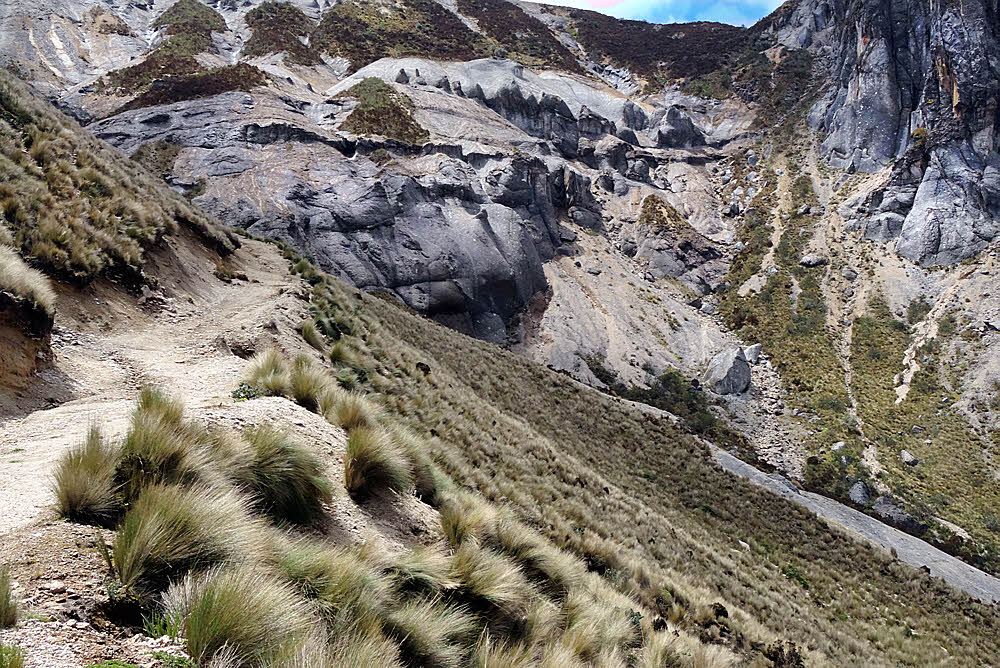
The Gearskin is a brilliant idea, just not finished. It was invented somewhere in the late 1990s, developed to the point that it was workable, and abandoned at the halfway point. It turned out to be especially awkward for someone using a hammock. I like to camp on slopes along the trail. Some of these slopes have been as steep as ye olde 45°, and that's steep. Difficult to even stand on, but near the trail, clean and unused, often with no underbrush, with a clear view all around, and quiet. And the trees on slopes often turn out to be big enough to hang from and also small enough to hang from. None of these six-foot-thick giants of the lowlands.

Yeah, right. But come morning, there's a problem if you're carrying a Gearskin: You can't hardly pack it.

See, the way you load a Gearskin is you lay it flat (go find some photos). This is cool on level ground but not on a slope.

You open the pack, which is one piece of fabric, lay it all flat, and arrange your things on top of that. Then you leave the back on the ground and fold the front up over it like folding a taco. Then you cinch down the side and top straps.

That doesn't work on a slope. All your stuff rolls away, and what can't roll slides away. To load a Gearskin on a slope requires a minimum of three arms, which means getting an implant or bringing along a manservant. Neither worked for me, so after sewing a few dickhead-stupid shelters I thought I was capable of making a pack that would work better.

Eventually I was.

The problem with the Gearskin was that it had no inside. Under the right circumstances it was trivial to arrange all my goods just so before cinching down the pack, but I didn't camp where those circumstances applied. The real beauty of the pack, though, was that it used compression to achieve rigidity, and so it didn't need a frame. I think that my Gearskin weighed 19 ounces (540 g).

I had started ultralightering with a GVPGear G4, another frameless pack, but I moved to the Gearskin because by tightening its compression I could firm it up enough to be actually usable. The G4 was a good introduction to light packs but not practical (which was part of the introduction). By carrying a hammock with an underquilt, I had nothing remotely resembling something rigid, so, unlike those ground-sleepers with closed-cell mattresses, I dint have nothin to use as a fake frame. Anyway, top-loading packs, if I may say so, suck bigtime. They're nearly impossible to load properly, and the more soft stuff you have the worse it gets.

Abstract view from above. Overlapping flappers on front. Expandable from square to trapezoidal.

I eventually developed the idea of making an enclosed pack body that loaded from the front. Among packs we have top-loaders, which everyone is familiar with, panel-loaders, which are seldom available, even the bad ones, the Gearskin, and my design. I call it a slit-loader. It's a font-loading pack with no panel. My first designs were both slit and top loaders, but I found that eliminating the big hole up on top firmed up the whole pack and didn't affect utility at all. Part of these results are due to the two huge side pockets that I build in. Add a small detachable pocket that attaches to the pack's front to carry the cookset and the day's food, and there is usually no reason to get into the pack body during the day anyway.

It worked. Best pack I've ever used. Weighed 20 ounces plain, or 22 ounces after I added a couple wooden dowels to act as vertical stiffeners (567 g and 624 g, respectively). I made a couple of two-week, 200-mile, no-resupply trips with it. That hurt, but the pack worked. When you're starting out carrying close to 30 pounds (13.5 kg) in food alone, the whole trip revolves around pain and muscle fatigue, and that's unavoidable, but the important part of the story is that the pack worked. It expanded to accept a bigger-than-normal load, and then carried it, uncomplaining.

Since the mostly-closed design meant that I could load the pack on any slope, I could place my equipment exactly where it needed to go, and keep it arranged perfectly until I was ready to compress it all. Things went in in layers through the front slit: sleeping bag first, flat and wide against the pack's back, providing cushioning, then the food bag, placed vertically, then the hammock/tarp/underquilt in an inverted-U shape around the pack's inside perimeter. Put the possibles bag up top, stuff clothing and rain wear in the empty spaces, and you just about have it. Then begin cinching down the straps until the whole pack becomes one solid wad, and go. Beauty, eh?

I miss it.

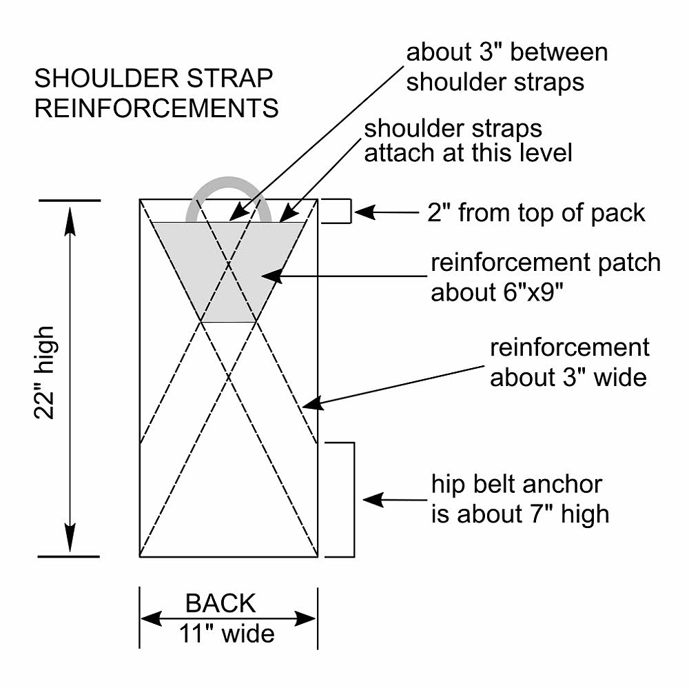
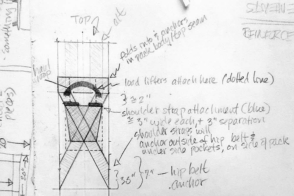
The shoulder strap reinforcements help to pull the pack together.

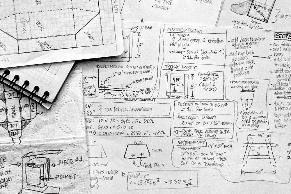
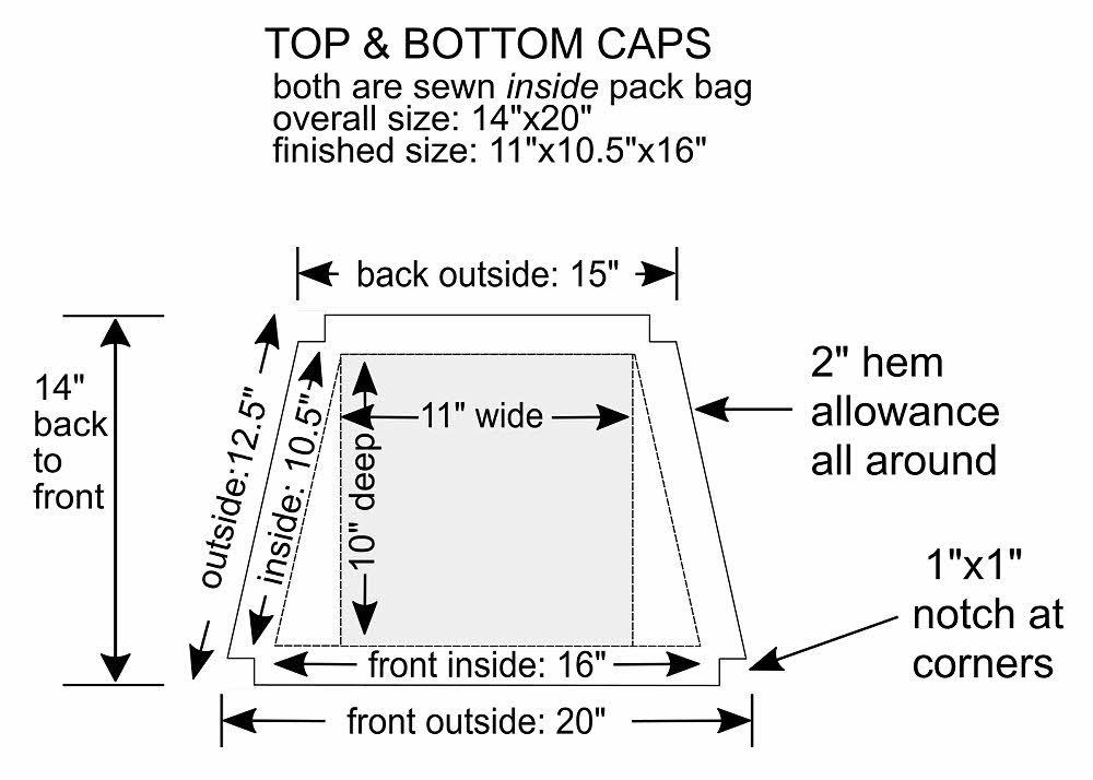
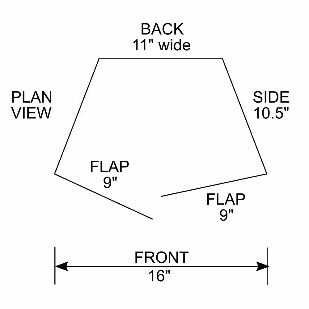
So I'm trying to resurrect Squeezo by remembering the design. That's easy. The hard part is that I need to have exact dimensions. They have to be reinvented, and my circumstances mean that I have only one chance. I have the fabric and hardware with me, but only enough for one try. The fabric isn't anything fancy, just utility nylon from Jo-Ann fabrics, but where do you find that or anything similar in Ecuador? Closed-cell foam padding? Buckles? Nylon webbing? I don't think so.

I bought a sewing machine for $180. It's probably a $100 model in the U.S., but I have it. I'll sell it for half price when I'm done, which will be soon, because I have an airline ticket waiting to be used. When the time comes I'll either have a pack to fly home with, or not.

I don't know what the problem is, but all the packs I've used since my last Squeezo have hurt a lot, in the shoulders. REI Flash 45, Golite Jam, Granite Gear Crown 60, Mountain Laurel Designs Prophet. I don't know if it's the sharp curve in my collar bone that's unique to me, or the narrowness and stiffness of the commercially-made shoulder straps, but it's been what? Five cases of extreme bone pain? Yes, five — screaming, relentless, all-day, endless collar-bone pain. I had to stuff extra padding between the straps and my bones, which remedied but didn't cure the situation.

I think my former Squeezo straps were wider. I based them on the Gearskin that I had. I don't remember how wide they were, and now I have to guess. At least I have the MLD Prophet to trace from, for strap shape and length. The width and padding details I can adjust when I make the straps, but it will have to be a guess, and I do have only that one chance to get it right. I have both stiff foam and soft foam, so I can use layers. I'm hoping.

What else? I don't remember. Am I making sense? Who can say?

But I'm going to try.

Postscript.

I have more images of a pack I built in 2015 from a "replacement" hip belt and shoulder straps I bought via REI, and stuff sacks I bought at Swain's General Store in Port Angeles, WA. I may post them at some time.

I will post instructions if I get this current pack worked out.

2009 Post.

No Pack Is Made For Me. Has photos of my dear departed Squeezo (insert tears here).

Tuesday, December 19, 2017

Who Says What? (See below.)

What the hey, why not? I've got all these links to various outdoor blogs, sitting here, so why not post them?

Someone may come along one of these days, by accident, and at least they'll get a few links to actually useful blogs. All of them are below — everything I've got.

I can't say which of the links are dead because what I use daily is on my Feedbin account, and I normally don't use these direct links, but I'd be more stupid than usual to delete them because every now and then I actually do need to go digging.

So anyway, not all of them are live, there may be a duplicate or two, and only a few might be interesting, and even fewer are useful. To me. You have your own needs, and if you, whoever you might be, can find anything of interest here, you're welcome to it.

Got problems with any of them? I don't want to hear about it. La la la la. The end. Thx, bye.

2 Foot Adventures

2 Schmucks on the Trail

2180 Miles

7Days6Nights

A Backpacker's Life

A Blog on the Landscape!

A Skirt In The Dirt

A Taste For The Woods with Neil Brennen

A Wandering Knight

Abraham Path

Across Utah!

Adventure Alan

adventure-inspired

Adventures In Stoving

Adventures on the Pacific Crest Trail

alan sloman's big walk

Alaskagraphy

Alastair Humphreys

alice hikes - and other stories

Allison Outside

Alltop - Top Outdoors News

Aloof

Alpine Mystic

Always Wanderlust

An Epic Ice Age Trail Adventure

Andrew Skurka

Andy "Fed-X" Thies

Another Long Walk

Appalachian Trail Daily

Appalachian Treks

Australian Trips

AWOL's A.T. Guide

BackCountry Journal

Backcountry Tranquility

Backcountry.com Blog

Backpack45's Musings

Backpacking by Bus

Backpacking North

Backpacking Technology

backpackthesierra

Backyard to Backcountry Adventures

Banana Pants' Trails

Banksian Sphere

Barefoot Jake - Wilderness Photography

BearCan.com

Bearfoot Theory

Bedrock & Paradox

Best Hiking Tips For Women Hikers

Big Outside

Big Steve & Lil Jan

BIG TRIP

Big Trip (German woman)

Big Wheel Building

Bigbananamountains

Black Coffee at Sunrise

Blissful Hiking

blogpackinglight

Bogley Outdoor Community

Bold Betties Blog

Booby Hatcher

Bounce in the Woods

Bowman's Writing Nook

BrawnyView

Brian and Ashley's Hiking Blog!

Brian Frankle: Dead Reckoning

Brian's Backpacking Blog

Brown Girl on the (P)CT

Buddy Backpacker

Bus Question

Bushwalking NSW

Cabbage of Curiosity

Campfire Chic

Canyonlands: Tales from Narrow Places

Captains of Us

CARROT QUINN

Cascade Crusades

Cascadia Hiking

Cass Gilbert: While Out Riding

Cattywampur

CDT To GDT Thru-Hike

Cesar and The Woods

Charley Zheng | a curious drifter

Charlie Knight

Chas and Chelsea Hike the PCT

Chris Townsend Outdoors

Clever Girl

CleverHiker.com

Coast to Coast Sweden

Columbia Blog

Cooking in Tongues

Cotopaxi Blog

Country Kyle

Crossroad

Dances with Angiosperms

David Stillman

Departed Outdoors

Dirtbag Diaries

dirtmonger

Dispatches From The Trail

distance makes

Doug Peacock

drj0nswanderings

Drop-N-Roll

Dzjow's Adventure Log

East West Hike

eathikerepeat

Eating Miles for Breakfast

ECT Thru Hike

Elina Travels

Endless Footpath

Endless streams and forests

Erik The Black's Backpacking Blog

Erin Wired Saver

eNZees Foot Soother Blog

Eric's Blog

Evergreen Trail Guide

ExpeditionDan

Fat Guy Hiking

FellBound

Fixing Your Feet Blog

FJADERLATT

Father Nature Outdoors Blog

Forest Hiker

Fork in the road

Forrest McCarthy

GearCaster

GearToons:

Geoexploits

Girl Gone Hiking

Going up the Khyber

Going Places Quietly

Goat Rocks Crest

Going Wherever It Leads

Golden Trout Wilderness

GORE-TEX Blog

Grid North

groundbird gear

Guthook Hikes

Halfway Anywhere Travel Blog

Hammocker UK

Have Tent, Will Travel

Her Odyssey

Hike 734

Hike It. Like It.

Hike Now, Work Later

Hike of the Week

Hike Guy

Hike Now, Work Later

Hike. Eat. Camp. Repeat.

Hikebiketravel

HikeLighter.Com

hikeminded

Hiken Girls

Hiker Adventures

Hikers For Life

Hikes 'n Stuff

Hiking Aint My Hobby

Hiking and camping in MD, PA and beyond

Hiking Dude Blog

Hiking Fiasco

Hiking in Finland

Hiking Life

Hiking the JMT

Hiking The Trail

Hiking With Barry

Hiking With Bigfoot

Hiking with Lipstick

HikingMike.com

Hikingsolo on the PCT

HoboKitten

Honeymoon on the Pacific Crest Trail

Hot Mama Hikers

How to Hike 2000 Miles

bootstobirks

Huckleberry Hiker

Hyperlite Mountain Gear Blog

i have walked here

I'm Jack Haskel

Idaho Trails Association

IndefinitelyWild - gizmodo

Indiahikes

Inga\'s Advenures

Inherently Adventurous

Injuring Eternity

Jan's Jaunts and Jabberings

Jay's Journeys

JERMM's outside

jnunniv

Jolly Green Giant

JRCAdventures

Just Two Hikers

Jason's Outdoor Blog

Jill Outside

Jovial Wanderer

Jan Smitowicz

Joe Newton - Exposure

Justin Lichter

Justin Lichter

KARMA on the Hayduke Trail

KARMA on trail

Keith Foskett

kenandcam

Kiwiscout Walks Aotearoa

Korpijaakko

Lady on a Rock

late bloomer hiker

Laughing Dog

Lawton "Disco" Grinter

Lessons of the Appalachian Trail

Life Less Ordinary

Life Peripatetic

LightHeart Gear

Lightweight Backpacking

Lightweight Hiking and Tramping Gear Lists and Trip Reports

Linda's Lens

Lint Hikes

littlegrunts.com

Living High On Life

Liz Thomas: Adventure Hiking

Lon.net

Lonewalker

Lonewalker's Walking Diary

Long Distance Hiker

Long Distance Hiking

Long Walks and Dirty Socks

Lost Coast Trail and the King Range Wilderness

Lotsafreshair

LovelinePCT 2014 Blog

LWPetersen

The Importance of Elsewhere

Making Waves

Mama's Basecamp

Mamma Quail Hiking California Bay Area

Mandie Hikes

marmotsadventures

Married to the Trail

Martin Rye

Mary Slosson

Metal Backpacker

Modern Hiker

Mountain Gazette

Mountain, Coast, River

Mountains and Miles

Mountains Are Calling = skirt chick

mrnayt.com

MSR Summit Register

MunroMagic

Must Be This Way

My Feet Hurt

My Very Long Walk

Myla Hikes

Nancy Hikes

Nate in New Zealand

National Forest Foundation

National Parks Conservation Association

New Nomads

Nimblewill Nomad

NoBo Hobos

NOLS Blog

North Cascades Backpacking and Hiking

Northern Walker

Not Waiting to Live

novanet

Off Route

Off the Beaten Path

Old Man Outdoors

OMails

One Swedish Summer

One Who Cannot

Onna Voellmer

Our Life Outside

Out there with Tom

Outdoor Adventure Gals

Outdoor Herbivore Blog

Outdoor Society

OutdoorsMH

Outdoorsy Mama

Outside Ed Blog

Overland Undersea Travel Blog

Pacific Crest Trail Journal

Pacific Crest Trailside Reader

Packraft Table Blog

panafoot

Paradise From My Porch.

PCTA: Pacific Crest Trail Association

Peachy Hiker

Peaked Curiosity

Pedaling in Place

Pie in the Sky - the pie's the limit

Pied-Ã -Terre

PilgrimChris.com

PopUpBackpacker.com

Postcard from Timperley

proud land

R U Nuts Adventures

Rambling Hemlock

REI Blog

Renee Patrick (She-Ra)

Richard Hikes

Rock. River. Run.

Rockieschick - Blog

Rocky Mountain Journal

Ron's Outdoor Solitude Blog

Outdoor Research Hiking & Backpacking

Old School Outfitter: Gear with Attitude

National Parks Girl

Sage Clegg Thru Hiking

samh

Sarah Marquis

Sarah Marquis, explorer - writer - speaker

Scottish Mountaineer logo

Scout Project

Seattle Backpackers Magazine

Sectionhiker

See Jen Hike

semi-rad.com

Shaded Trail

She-ra Hikes

Shepherd on the Trail

shepherds blog

Shooting Star

Sierra Hikes!

Signpost Blog WTA

Silky's Blog

Sirena's Wanderings

Slot Canyons of the American Southwest

So Many Mountains, So little Time

Sobo-Hobo

SoCalHiker Hiking Guide for Southern California

Southwest Ultralight Backpacking

Spirit Eagle

Spreading my Wings

Sprinkles Hikes

StaciaWanderlust

Stay Sane. Sleep Outside.

stephenolshansky

Stueby's Outdoor Journal

sub-10

Suburban Bushwacker

Summit Hut

Sunny Side of the Alps

Survival: Wildwood Survival

Sweeping the Garden

sweetwilder

Talusfield

tandem trekking

Terry Bliss

Tess Gone Wild

tgsg Blog "How many summers do you have left?"

Then The Hail Came

Things To Luc At

This Hiking Life Blog

This Makes No Sense At All

Thought Droppings

Thunder In The Night

toward simple

Trail Climb Nation

Trail Mix and Dirty Underwear

TrailDirt

Trail Kit

Trail Skeptic

Trail Recipes

Trail to Summit

Trail Updates

TrailGroove Blog

Trailhiking Australia

Trails and Tracks

Tramping in the New Zealand backcountry

Tramplite's Travels

Traveling By Trails

Traveling Mandolin

Trek on the Trail: Rabbi Yaakov

TrekkingIn blog

Trying to Die a Bored Man

Two Hikers: Western Mountains

Uk Backpacker

Ultimate Hang

Ultra-lightweight hiking and backpacking

Ultralight and Comfortable

UltraLight Backpacking or Bust!

Ultralight Hiker

UltraPedestrian

UltraPedestrian

Uncalculated Life

Unconventional Life

Voigt's Voyage

Walk Outside

Walking Archives

Walking With Wired

walkingwomad

Walks with Moss

Wander Women

WanderFroh

Wandering Knight

Wandering On The Edge

Wandering the Wild

Wandering Virginia

WasatchWill

Weekend Woodsman

Weird Life

Wenatchee Outdoors

Wesley Trimble

Where's Lori

While Out Riding

Whiteburn's Wanderings

Wild Whatcom

WildernessDave

Wilds Project

Willis Wall Blog

WinterCamper

Within Walking Distance

Wood Trekker

Woods Life

Wrong Way Gang

Yeti rides

Zenlightened Voyager

Viajar a Pie


Photo blogs...

Alexandre Buisse Mountain Adventure Photography

Circa 1983 - Owen Perry

Cody Duncan Photography

David Lintern

Eric E Photo

Hiking Photography

joebeckerphoto

Jonathan Bjorklund

Phlumf

Niebrugge Images

Photo Cascadia

Random Adventures Blog

Roving Light Travel Photography

Tim Ernst - Cloudland Journal

weathercarrot photos

Wild Lens Blog

Thursday, December 14, 2017

Rainier Photo Dump, 2007

These are photos from my second trip around Mr Rainier. I think this first one is from Reflection Lakes. (Hints? What were the hints? Reflection — probably a good guess. See the "Wilderness Trip Planner & Map", below. The map is on the PDF's second page.)


Stevens Creek

I have to work from the map. This was a while ago now, 10 years, and although the emotions are still fresh the details aren't. The image just above is of lower Stevens Creek, which is pleasant to hike along.


Moving north along Cowlitz Divide toward Indian Bar on the east side.

During the winter of 2006-2007 there was a huge amount of rain, almost 18 inches (457 mm) in a sudden 36 hours, according to the park's web site. That had effects. "The flood destroyed most of the park’s low-lying trail bridges. Major sections of trail collapsed or were scoured down to bedrock, and will need to be rerouted or rebuilt," said the park's web site shortly after the event. Entire sections of road also went missing.


The drop into Indian Bar.

As I recall, the Wonderland Trail was closed during the whole 2007 hiking season. I didn't even think about it aside from hearing a couple new reports.


Indian Bar, my favorite place.

Then, sometime in August of 2007, maybe late August, or extremely late August, suddenly the Wonderland Trail had been repaired, mostly, and was open again. Woot! No bugs or competition. Since I lived nearby, all I had to do was to show up. Everyone else had given up for the year and gone into their winter dens by then.


I don't know what these — maybe a sort of gentian.

So, a no-brainer. I hate fighting for permits. I prefer National Forests to National Parks because, if anything, all I need to do is to fill out a free permit at the Forest trailhead and not die out there. You hike and then go home when you're done and no one knows what you're up to or bothers you, and doesn't really care. National Parks are fussy, and many, like Rainier, have quotas.


Looking back to the south across the Indian Bar area while headed north.

Given that, I also deeply prefer going where other people don't. That usually works. You see things when you go to unpopular, ignored, and dismissed places. Some of the most rewarding times of my entire life have come about just by sitting down somewhere and keeping still. You can't do that when you're fighting to see famous roadside attractions, whether those "roads" are either congested highways or congested trails.


Looking to the west, toward the center of the park the mountain while climbing out of Indian Bar.

Roadside attractions are generally crap anyway. On my first trip to Yellowstone in 1977 I stopped about every half mile, got out of the car and took a look at whatever the signs pointed to while bumping shoulders with everyone else. It made me crazy, but I caught on. On my second morning there I climbed the hill behind the campground and walked along a stream. There was no trail. There were no signs. Nothing pointed at what to see. No people. No buses. No horns. Nothing official. No stress. It was fantastic, a great September day. On the hike back I took off my clothes and splashed around in the creek, then sat on a rock and sun-dried. Perfect.


Climbing the pass between Indian Bar and Summerland.

Rainier in early September of 2007 was like that. I had free run of the place. No one gave an official eff because almost no hikers were there that year, especially after Labor Day, which is normally quiet anyway. I did see one ranger at about the halfway point, but she ignored me. Usually rangers ask to see your permit, at a minimum, and maybe ask questions to make sure you're doing what the permit says. This ranger was talking to another person, maybe a day hiker, and I can't remember if she actually even looked at me. Choice. Sweet. Most excellent. Just the way I like it.


Same area, different view, looking up and back the way I came.

I got lucky in another way too. I went counter-clockwise from my starting point at Longmire. During my first night, near the Nickel Creek camp, I got a few sprinkles on my hammock fly, but no more. Somewhere along the route I met a guy who had started at roughly the same time as I had but who went in the other direction. He had been on the windward side of the mountain and got to enjoy a couple days of rain. I was hiking in the rain shadow and got fog and crazy-wonderful clouds without all that rain stuff. Choice, Part Two.


More atmospherics along the way to Summerland.

I got super-lucky in another way too, despite personal stupidity. Adventurous stupidity, something I specialize in. Even after much trail repair, the part of the trail in Sevens Canyon along Stevens Creek was still closed. You pass Reflection Lakes, do some trail hiking and a little road walking, then pick up the real trail and head down Sevens Canyon, but not in 2007. That lower trail was closed — some parts of it had been washed away. It meant several miles of road walking.


The drop into Summerland.

Well, I flubbed it. I got confused by the signs that said hikers should take to the road, and I instead continued along the trail. I thought that the signs were a sort of "heads-up" to indicate that the detour was coming up "real soon now", but that was the actual real detour, and the trail there looked fine, so... By the time I came to the massive trail washout I didn't feel like backtracking, because I'm dumb, so I used my shoe edges and fingernails to dig into the slope just enough to keep from rolling down the 45-degree slope of hard damp subsoil onto the rocks along the creek, about 100 feet (30m) below. Well, hey. It was maybe 100 feet down the slope, not a full 100-foot vertical drop, and maybe only 50 feet to go horizontally across the washout, at most, and in the world of non-news, I made it, using up some good luck I didn't deserve. The rest was easy.


It seems like this view is much farther along, but I don't recall just where, so hey again. It was nice. That's enough.

Later on, much lower down the canyon, there was some confusion. But no people. Since I was on a closed section of trail, it was bliss in that respect. Super-doubly quiet.


Evening slightly upslope from the Glacier Basin camp.

The confusion came in a flat area where Stevens Creek had gotten its hair mussed by the previous winter's flooding. The trail was washed out in spots, or covered by debris, and the creek had re-routed itself several times — hard to tell where the real channel was, let alone the trail along it. I had to hunt for the trail. At least I knew that no matter what, the way to go was downstream. Whenever I lost the trail I found it again after a bit of stumbling around. Not bad.


Near or on or approaching Burroughs Mountain (to the right, I think). Nice place.

So there I was, down in the flats and it was all mixed up yet again, in a tangle of uprooted threes with two or three possible stream channels to choose from and no trail in sight. To get a better gander at things from a few feet up, I stood on the trunk of a fallen tree. About three feet up. Then I lost my balance and fell over backward. This, generally speaking, is not usually a good thing. It's surprising how fast it happens.


From Burroughs Mountain looking back east the way I'd come, in the direction of Sunrise.

I did manage to step backward as I fell off the horizontal tree trunk. I did get both feet off it as I fell, somehow. And then I hit the ground. Feet first, also a good thing, but my body was rotating backward, with my feet as the pivot point. So the next part of me to hit the ground was my tail, then my pack. So far things had been going well, sorta. But the pack rocked me backward when it hit, and my head whipped around just before the back of it slammed into the ground.


I'm not sure if that peak at the left-center is Little Tahoma or not. Could be.

And, in yet one more stroke of luck, that ground was a soft pillow of sand, so I didn't die immediately. After a few startled seconds of lying there on my back, I turned my head to the right and saw a water-smoothed watermelon-sized rock humped out of the sand exactly beside my head. Not more than six inches (150mm) away.


This is probably Winthrop Glacier. It would have been fun to get to that last ridge.

Dying quickly isn't so bad, and I probably would have if I'd come down on stone, but being still alive, I had second-tier concerns — more worried about my retinas than anything else. If it's one thing I am it's nearsighted. You get that way when your eyeballs are elongated, which stretches your retinas like crazy. Any bang on the head at any time and several other causes can inspire these retinas to cut loose like over-stressed rubber bands, and then it's all over, sight-wise. The other possibility, after that, was a concussion, even after bonking on sand. I did have a mild headache for the rest of the day but since I've made it for another 10 years, so far, I'm not worrying about that any more. Call me Stumbling Ed Dufus.


North of Burroughs Mountain, southeast of Berkely Park.

OK then. That was the first day. Aside from two or three sprinkles of rain that night, nothing happened. Lucky, lucky, fine and plucky, me. But mostly lucky, and way dumb in parts.


Carbon Glacier, several miles farther west.

Farther along, up the east side of Rainier and north, the trail passes through Granite Creek camp on its way west, then Mystic Camp, and then it parallels Carbon Glacier as it heads north, passing the Dick Creek and Carbon Glacier camps, all nice places. (Check the map link.)


Mommy marmot. She and her little one munched nibbly bits along the trail as I tried to act not-dangerous and sidled by only a few feet away.

I don't remember all the camps I've been registered at in my two trips around Rainier, but I've stayed in only two of them. I guess I'm a minor outlaw, but hammock camping at most national parks is almost impossible. On the first day of my first trip I encountered a ranger while crossing South Mowich River. He was stationed at Golden Lakes where I was registered for that night, and checked my permit, so I had to show up. It took around two hours to figure out how in hell I could possibly hang my hammock there. I managed, but it was tricky. Great view though.


Morning, somewhere between Carbon Glacier and Mowich Lake.

The other camp was Glacier Basin in 2007, which is on a spur off the main Wonderland Trail, and had only one other set of visitors there that night, off on the far side somewhere, and was decent. Most of the camps I've seen are right on the trail. The trail either skirts them or goes right through them. Yeeg.


Spray Park area.

I prefer to either stop a bit short of a camp or go a bit long. That way I can claim that I'm just exploring, or haven't quite made it into camp yet. Either way, I look for a good spot, check to make sure that no one is around, and melt into the landscape. In the morning I quietly drift back onto the trail and continue hiking. It isn't what is supposed to happen but camping that way is a lot nicer and even if anyone saw my campsite after I left, they'd never know that anyone spent time there. National Forests and other "free range" areas make it easier.


Spray Park area.

During my 2007 trip, I stopped my second-to last night in the South Mowich River area. There are some braided streams there, and I was able to slide off the trail and have a wooded sandbar all to myself. By that time I hadn't seen another person for almost two days, but discovered the next morning that I'd been visible from the trail. Still, I had no problems and don't think anyone had come within miles of me. Pure luxury. Usually this kind of space and privacy are only available in totally unfashionable places.


Somewhere near Klapatche Park I think — on the east side anyway.

I suppose this trip was unique. Unless there is another bad winter bringing severe damage I'll probably never see such a wide open chance to explore Rainier. In late September, 2016 I was looking for one last hike of the season, but a storm was blowing in, so I didn't try.


I'd like to give this a name but it could take weeks of research, so let's just call it Fred.

I did check the various Park web cams, but even a few days ahead of the real storm, there was blowing snow at the Wonderland Trail's elevation. Obviously out of the question, even for someone as prone to doing stupid things as I am. So I folded. Why push it past the limit?


I guess this is on Tahoma Creek between Devil's Dream and South Puyallup River camps.

It's the same idea as avoiding world-famous places and the crowds that go with them. So I checked my notes and decided to try the Three Sisters Wilderness in Oregon. That worked. Nice area, but again, it was late in the season and because of that, the hiker population had been severely trimmed back. Even so, several areas were crowded. This would be hell in summer. Signs everywhere. Restrictions to the left of us, restrictions to the right of us. Speed limits, no-parking zones. Traffic lights. Almost.


There is a story here. Betcha.

I did have a nice four or five day window of great weather out there in central Oregon, visiting a place I'd never been at all close to before. The bad weather eventually did blow in but only on my last day. Not bad. Unlike what can happen on Rainier. Rainier is completely exposed to whatever the Pacific Ocean pitches at it, and conditions are always iffy. Central Oregon is much farther inland, better buffered from western weather, so that was a good choice at that time. Still, I really would like to get back to Rainier again. Maybe 2018. Maybe. I'll think about it, I will.


More info from MORA.

The Wonderland Trail (info)

The Wonderland Trail Profile Map

Wilderness Trip Planner & Map (includes trail mileages)

Park Map

JPEG Shaded Relief

November 2006 flood ("old page")

November 2006 Flood

Images of the Flood of 2006

Wednesday, December 6, 2017

Been There?

Roadside Wonder Semi-National Park And Aquatic Center

I thought the ranger was cute, but then I noticed that he had too many toes on one of his feet. He was wearing heavy boots so I couldn't be sure, but I'm sure. I'm never going back there unless I don't have anything better to do. No convenient outlet malls for shopping either. P.S. Mom warned me but I didn't listen. Thanks for nothing, Mom.

— Bradley


Rocky Canyon National Park

Pretty much what you'd expect from a hole in the ground, and they still charge admission besides. I'm telling all my friends so they don't have to as well.

— Bethany-Ann Morgul


Sir Francis Ozark Non-Representational State Forest, Arkansas

Not bad if you're into modern dance and abstract art but I got indigestion. Maybe I licked off too much of the finger paint. I think it was the orange. Avoid the orange, otherwise you'll probably be OK. There were some bugs too. Just off Highway 12½. Turn left at the big barn and ask for Joe if you really feel this adventurous. It helps if you know sign language.

— Rupert (I'm an accountant in real life.)


Scrubland Regional Desolation Area and Provincial Toxic Waste Reserve

I think this was in Canada or someplace. I don't remember how we ended up in a foreign country if that's what it is. Dad just gets us in the car and drives, you can't even talk to him. So after about a day and a half he just stops and sort of falls out of the car and there we are. Nothing to do there except it got more interesting when we all started developing skin lesions. Then somebody came and took us into town. We had a few hamburgers but the french fries were not that good plus the money looked weird and stuff. I'd rather watch TV. Never going on vacation again unless they have a real roller coaster. They kept Dad. Said he was unusual or something I think. So far we don't miss him that much.

— Charles


Bug Infestation County Park, Kansas

I ate something on a stick. I thought it was cooked but then it started moving but I was hungry so I pretended that I didn't notice. It had feelers. They kinda tickled. I usually work in an office so this was all new to me. I just hope I didn't catch something while I was there.

— Sally


Mount Rainy National Park

WTF!!!! NO RAIN!!! Plus there's this big honking mountain you have to drive around or you can't get anywhere. Anyhow I hate rain so I don't know why I even went there in the first place and there were lots of people like hanging out like they were waiting for something or something but there weren't any geysers or anything just this mountain with some like glaciers or something way up there and it was too far to walk and it's only glaciers and stuff anyway. We're never going back.

— Theresa and Cuddles


Stomach Cramps Roadside Rest Area, Missouri

The name pretty much says it all. We stayed for a week until the Sheriff came and kicked us out but he kept my Howdy Doody Commemorative 10th Anniversary publicity photo signed by Buffalo Bob himself in 1957 and I for one will never forgive him for this.

— Walton James Thurber III


Death Valley

Over-rated. Nobody died while we were there. Avoid if possible.

— Valentina (I used to be a ballet dancer!)


Fallen Arches National Park

This is the other one. It's in Iowa. You go there expecting an adventure but all they do is try to sell you overpriced insoles. It isn't even a National Park. I checked. Totally phony but I did meet an interesting guy there. His name is Rolf — used to be famous back in the 60s. Kept trying to get me to come out behind the shed where he promised to show me his energy field. It's true that magnets stick to him, I saw it, but I'm not really into that anyway. I'm more of a shopping person so we parted ways. I got a great deal on a pair of patent leather flats (black) covered with ladybugs so it wasn't a total waste except all the ladybugs ran away right after I paid for them. Kind of a bummer.

— Rawya Lindstrom-Tuttle (Not my real name, lol!)


Pretty Large Dismal Swamp, Virginia

Not a world-class place. I've personally gotten far more depressed at work, and without so many snakes around, and there's no Starbucks nearby. Poor humidity control too, if you ask me.

— Olivier


Samson Agonistes Tragic Roadside Theme Park, Colorado

Wish the show had gone on longer. Six hours is definitely not enough time to do justice to this magnificent story. Very clever use of sock puppets though.

Does have a few kind of clumsy lines, like:

Then with what trivial weapon came to hand,
The jaw of a dead ass, his sword of bone,
A thousand foreskins fell

So you may want to prepare yourself for awkward questions from the kids, just a word to the wise, but they make their own popcorn fresh for every performance and Dalila was a major babe, especially for a character made from wool hiking socks, and I'd like to know who Samson's hair stylist is since I've got this awkward bald spot, but I probably should have just bought one of the souvenir wigs. Oh, well...

Also great: Manoa the Father of Samson, Harapha of Gath, and the Chorus of Danites. Best Chorus of Danites ever, but when we finally did crawl into our sleeping bags about 3 a.m. the guy in the next tent's snoring pretty well kept us awake all night, and there was apparently a little swordplay down by the restroom area which was not at all soothing either, but I have to admit I really did fall for the beer-flavored ice cream and was completely enraptured by almost all of the serving wenches.

The wife of course totally got into the main dude and absolutely had to have one of the official life-size Samson-replica dolls, but I wouldn't let her bring it into the tent. She wanted all of us to "snuggle" and so on. Wait til we get home, for crying out loud, at least, I told her.

I'm sure we'll be spending a few nights working through this one.

I'm definitely going back though. Maybe without the wife even. We'll see. Thursday maybe. Love those wenches.

— Walter


J. R. Simplot America's Favorite Side Dish Hot & Spicy Golden Brown Tater-Togs National Forest, Idaho

Lots of stumps, and if you like beef stroganoff, you're not getting it here.

— Leslie


Oh So Oso Chocolate-Flavored Fruit Punch Tufted Auditory Appendages National Monument and Uranium Mine

We had a fun tour of the pit. It's not every day you get to drive your own rented jeep around in a working uranium mine and visit the therapy chamber of your choice. "Bring back that healthy glow," the sign said, so hey — worth a shot. I still feel a little buzz going on, and it's been six weeks now.

This used to be called Hoon‘Naqvut, or Shash Jaa’, or Kwiyagatu Nukavachi, or maybe Ansh An Lashokdiwe (they couldn't seem to decide) so no wonder they changed it. In English it's supposed to be like "Bears Ears", so why couldn't they just say it? The story is it used to be sacred or something. Mostly dirt. Sacred dirt, I guess. Whatever.

Got boring after a while, so we spent most of our time in the cafe and gift shop trying out the drinks. Brought home a sixpack. Lots of teddy bears for sale. Any kind you could want. Best variety I've ever seen, all imported, which makes up a little for the vast wasteland outside the plate glass windows. Oil wells and off-road racing could only be an improvement here.

If you visit, don't miss the Ryan Zinke Memorial Restroom, which has the only diesel-powered toilet I've ever even heard of. It also has a nice portrait of a recent President hanging inside to inspire you.

— Hamish Enfilade (I'm not from around here so don't blame me.)

Thursday, November 30, 2017

Cajas High

For a little while last summer I had some hiking buddies. We went to a few places like this. It and similar areas are in or near Cajas National Park west of Cuenca, Ecuador.


This was our big day, and last real hike, when two other friends of Mark showed up to accompany Barbara and me. Mark's little Chevrolet Sail was full to the gunwales.


I'm not really sure where we went. Not too far out. Mark, a Brit who is living in Cuenca, had been hiking on his own and knew some places. This one was fun because it was almost kinda-sorta strenuous.


We were able to park at a sort of odd little restaurant, fishing hole, hiking location and probably more called "Rancho Hermanos Prado", right along the highway. And since it is owned and private, and there are people around all day, it's a safe place to leave a vehicle.


Unfortunately, I decided to beg off the next trip to leave room for others, since Mark said he had to turn away a couple of people this time, and after that things sort of petered out somehow. Barbara is from Calgary, Alberta. She has seven dogs, all of which she was sane enough to leave at home. OK by me.


Several years ago I was out on another day hike along the same highway, and got up to 14,000 feet (4300m). I don't know how high this location is, but if you're acclimated it isn't a bad little trek. There is plenty to see.


Like little orange and yellow somewhat-crocusy flowers, evergreen shrubs, ridges, mist, hail, torrential rain, and wind. It has weather, and whether or not you're going to get some is not an issue. The only issues are what, when, and how much. It didn't hit this day until just after Mark dropped us off back in town. I got semi-drenched walking home even under my umbrella.


Rock. There is lots of rock. This is a volcanic area with frequent earthquakes. The land gets created and then endlessly churned. Meanwhile there is plenty of rain, and then things grow — sometimes unfamiliar things. Unfamiliar to me, but pleasant enough.


Up at the end of this hike there was some sort of radio equipment or an automated weather station. I have a couple of photos but left them out since they aren't too interesting in themselves, but there is something at the top, and the end of the road, such as it is, is there too, reasonably. So that's where we stopped and had a snack.


The ground is strange to me. It looks lush and vegetation-covered, and it is in a way, but get up close and the ground is mostly bare, with a layer of small, whitish, broken stone and scattered bunch-grass and shrubs.


Where there is low vegetation, it is green, but not soft and cuddly like moss. I'm not sure I've seen anything you could call moss. It isn't like that.


Touch it and it's hard. This isn't a soft landscape. All the plants feel like they're made of plastic.


Maybe it's the wind. This is a high place. Even if the days don't ever get warm, let alone hot, and there is plenty of rain, there is always wind, and so little atmosphere that what free water does coat the ground evaporates quickly. It's a land of succulents and pricklies.


No trees either. Not this high. But lots of empty space. Lots of vistas.


The good/bad news is that this area is easy to get to from Cuenca, costing less than a dollar each way to hop onto an intercity bus, but you have to speak Spanish and don't want to travel alone. My hearing is so poor that I'll never be conversational in Spanish, and it's hard to find anyone who likes to actually go out and hike in the dirt.


Once you do finish a day of hiking, you simply walk back to the highway and wait for the inbound bus to come along. Flag it down, pay a few cents, and end up back in town. But not so much if you're one person. Two or three or more, OK — but for one person out on the road, standing there all alone, anything could happen, and some of it less than agreeable, so I've been SOL for most of my time here. Haven't heard anything from Barbara or Mark for many months now. Due to leave soon anyway. This might be the last of my hiking here.


More info.

Cajas National Park

Páramo

Rancho-Hermanos-Prado