Disappearing quietly.

Getting up early to reach the edge of Hellroaring Valley, I enjoyed calm, cool air and warm sun. No day hikers were around. I could hop off the edge, drop a couple of feet, and head down slope.

The book "Trekking Washington" was my guide. It said though this part of the route was on Yakima land, there were no permits needed. Just to be safe I wanted to get over the edge and vanish before anyone was around. Ten minutes into Hellroaring Valley I would be invisible and, if not, then uncatchable. As well as being out of earshot.

The slope is mostly dirt, but you can call it scree if you want. You descend rapidly, and can soon vanish into scattered trees. After that you need to figure out where you are and where you need to go.
Too far right, down valley, and you come to a cliff. Too far left, and you are too high and are on bare rock and I don't know whatall.
Somewhere in the middle you pass among groves of trees, skirt shrubs, and work down in just the right way, and then, at the bottom, there's a drop. Unless you go a little more left, and slither down a seasonal channel.

This is fun. The route across the valley floor (there is NO trail here) skirts the edge of heavy rubble on the upslope side and willows on the downslope side.
I say rubble because it is. Boulders. Sharp basaltic boulders. Even so, there are many berry vines and dropoffs where hidden creeks cross the route. The going is slow unless you want to snap off a leg. Which you can do, but if you are there alone that will be the end of your story.

There is a nice spot on the north side of the valley where I've stopped twice for breakfast. But nice is relative. Nice for me is flat enough to sit down under a tree just barely large enough to provide shade. Nice because no one else can possibly be there. Ever. And because it is morning and clear, and it is good to eat.

And then you try to get out.
This is harder.
The north wall of the valley is mixed. Dead, scratchy brush down low. Hard dirt and some grass higher up. Steep. A few shallow ravines. Boggy ground guarded by impenetrable willow thickets. I've had to crawl. And it's really hard to tell where you are or where you need to go, because you're inside it, and can't see up. Things get steeper toward the top - more bare ground, more real trees.

You are now atop the Ridge of Wonders. So called. East is Little Mt Adams. It is windy. There is still a longer than reasonable trudge up, toward the mountain, toward the edge. The wind increases. You come to the edge and wonder. You wonder if this is the day you are going to die. You wonder because. There is no way down. Except. Straight down.
Then you understand. Why. It is called the Ridge of Wonders.

You could call it talus but it that is not what you see. What you see is boulders. Rough tetrahedrons, all sharp. A near-vertical boulder field. They range in size from cantaloupe to beach ball. They are loose. They are waiting to bite you and knock you down and then kill you. But this is where you want to be.

If you go slowly you may live. You hope to because there is so much more to see. You descend, one step. And then another. It takes at least a half hour to descend. The vertical distance is 200 meters, or more. Possibly 300 meters. It doesn't matter.
What matters is getting to the bottom before you die. Given enough luck, and willing yourself not to make a singe misstep, you do that, and it is glorious. You are now fully in the embrace of the mountain. You see its secrets. You cannot go back. There is water.

The first stream is clear, smooth, and barely deep enough to scoop from. It has no name. Across the valley is Big Muddy. You can hear it. You know its name. You know it is there.
It knows you are here. It owns this valley. If you come too near it will kill you. It will kill you dead if it can, and it can. It is brown. It is brown the way no water can be brown but it is. It foams. Standing near it but not too near it you realize that you cannot go on.

You realize that you cannot go on because standing there, on the edge of Big Muddy, but not too near, you hear it grinding. It could be grinding its teeth but it has none, so while it dreams of teeth, and of grinding you with them, it rolls together boulders and cracks them in its cheeks. Thunk. Crack. Chunk. You cannot go on or it will break you.
And while you cannot go on, you cannot go back. This is also fun. This is desperate living.

So you go up, skirting Big Muddy Creek. Looking for a way across. Because. Because if you go high enough, surely. Surely there will be a spot to cross. But there is not. Big Muddy Creek is smarter than you, and millions of times stronger, and older than your species.
So you go up, continuing to skirt Big Muddy Creek, and the first year, you find a boulder. It is split, and Big Muddy Creek, all of it, roars through the split. If you are careful. And lucky. And careful. You can drop to all fours, and reach your front legs across and shift your weight, and push off, and bring your hind legs across. If you are careful. And lucky. And do it just right. Then you will cross and not die.
And the second year that boulder is no longer there. Such a big thing. Now so absent.
The creek has killed it and eaten it and from it has made mud.
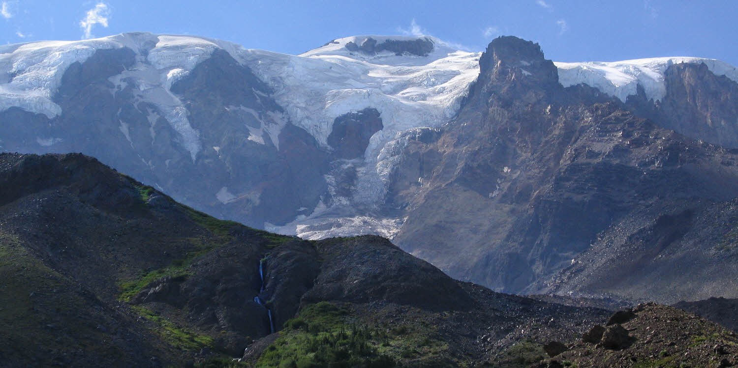
So you go higher, continuing to skirt Big Muddy Creek. Until. You come to the glacier. And still there is too much water. Clear, but cold with the cold of freezing cold, and too deep. And too fast.
It too will kill you. It will grab you and pull you in and freeze you hard and snap you into splinters and that will be the end of your story forever.
So you go up onto the glacier. And walk over its top, over the ice tunnels roaring with freezing death water, and that is how you get across Big Muddy Creek the second time.
You are lucky, and alive. It feels good to be alive, and to be lucky, and to be caught with no way out but to go on. But most of all, to be alive.

Given that, you go on. Time to climb out of the valley, which is easy, but hard. Finding the far side of the glacier, which is exceedingly small, for a glacier, it is safe but awkward to gain altitude trudging along its northern edge, where ice meets its moraine. Now, in these late times, the moraine is much higher than its glacier, and all dust. That is the way out.

And that is about it for today. Battlement Ridge has trees for hammocking, and a few flats good enough for a tent or two. From there, from the top where you are safe, you can look back at the land you came through, and look north too, toward tomorrow's Rusk Creek and its valley.
And while there is no water on the ridge, it is not hard to carry up a night's supply, and it is not hard to have bathed before getting there, and it is good to be there and be alive, so you sleep.


Previously: